Road Indicators
GeoClimate offers a processing chain to compute road traffic indicators based on the table Tool 2.5 (WG-AEN method) described in the Good Practice Guide for Strategic Noise Mapping and the Production of Associated Data on Noise Exposure Version 2 (13th January 2006).
The chain uses the GeoClimate road layer and a configuration file that contains information to establish relations between the WG-AEN referential and the road layer features:
a mapping from WG-AEN road types to the road layer types (WG type)
the CNOSSOS-EU pavement codes according to the surface values available in the road layer (WG pavement)
the Tool 2.5 flow data by WG-AEN road types for the 3 periods: day, night, and evening (WG data flow)
the maximum speed value according to the WG-AEN road types (WG maxspeed)
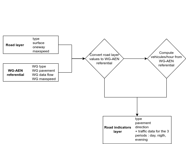
Figure 3. Processing steps to compute a road traffic flow based on WG-AEN referential
For each road geometry, the road layer generic fields type, surface, oneway, and maxspeed are mapped to the WG type, pavement, and direction as defined in the WG-AEN referential. These values are then intersected with the WG data flow to compute the number of light and heavy vehicles per hour for the 3 time periods:
Day (06:00–18:00)
Evening (ev) (18:00–22:00)
Night (22:00–06:00)
The 16 resulting indicators are stored in the road_indicators table:
The WG-AEN road type
The pavement code
The direction of the road section:
1 = one-way road section, traffic flows in the same direction as the slope definition
2 = one-way road section, traffic flows in the opposite direction to the slope definition
3 = bidirectional traffic flow (split between uphill and downhill)
The number of light vehicles per hour for day
The number of heavy vehicles per hour for day
The light vehicle speed for day
The heavy vehicle speed for day
The number of light vehicles per hour for night
The number of heavy vehicles per hour for night
The light vehicle speed for night
The heavy vehicle speed for night
The number of light vehicles per hour for evening
The number of heavy vehicles per hour for evening
The light vehicle speed for evening
The heavy vehicle speed for evening
The slope (in %) of the road section
GeoClimate - documentation 2020 - 2025 -  This work is licensed under a Creative Commons Attribution-ShareAlike 4.0 International License.